The internet is full of fantastic maps that inform, inspire, and get your brain working in new ways. These collected maps are all at the top of their game, selected for using GIS technology in novel ways to create new understandings of the world. From geologic landforms to population growth and radio, food, weather, and satellites – these amazing maps use GIS to explore the world.
6 Best Online GIS Maps:
- 1. The Human Reach →
- 2. Washington’s Ice Age Floods →
- 3. Windy →
- 4. Satellite Map →
- 5. Radio Garden →
- 6. The Food Capitals of Instagram →
1. The Human Reach →

Platform: ArcGIS Pro
The Human Reach creates an interactive picture of the many ways humans have marked the Earth. The map starts with population and urbanization. It shows light in the night sky and our different networks: roads, sea lanes, cables. It ends in some measures to bring all that together. This map project creates a guided tour of a set of interactive maps. At any point, you can pause the tour and go exploring on your own to answer your questions.
This map is best for seeing how different datasets can be linked together to tell a story.
2. Washington’s Ice Age Floods →

Type: Story map
Platform: LiDAR and ArcGIS Pro
The Washington Geological Survey created this series of interlinked maps to illustrate one of the greatest flooding events in American History. The maps examine the Missoula Floods which started in Montana, moved across Idaho and Washington, and into Oregon. They connect the big picture of a glacial flood to the individual landscape results, which are better understood through LiDAR imaging. The flow of the water is written in canyons, drumlins, and a huge, ancient waterfall.
These maps are best for linking the global scale events to the tangible local landscape.
3. Windy →

Type: Weather map
Platform: Earth and OpenStreetMap
Windy is a live, global weather map. This map has real beauty. Watching wind movement in real-time is relaxing and hypnotic. You can play around with all the normal weather data inputs: cloud cover, temperature, etc. You can also see how air pollution, like particulates and ozone, interacts with the weather. Together, these layers are put to their best use, allowing the reader to visualize, analyze, and reach greater understandings of global weather.
This map is best for utilizing the powers of layers and seeing what a small group of creators can invent.
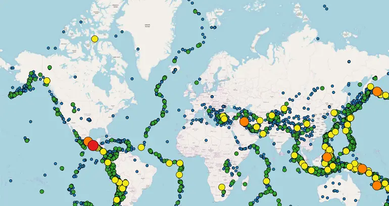
4. Satellite Map →

Type: Space map
Platform: ArcGIS API for JavaScript and Bootstrap
The Satellite Map expands the earth out into space to include the many satellites that humans have launched into its orbit. You can sort these satellites by country of origin, size, period launched, and even if they are working or junk. You can click on any individual satellite to view its orbit and pull up detailed information about it. The sphere of human influence has grown and the Satellite map shows that our maps need to grow with it.
This map is best for expanding understanding of our planet out into space and taking mapping extra-terrestrial.
5. Radio Garden →

Type: Interactive map
Platform: Cesium 3D Globe and ArcGIS
Radio Garden is a worldwide map of radio stations without national borders. You can explore other countries or your back yard and play streaming radio from anywhere. This started as a project to create greater international understandings, expanding the border-crossing nature of radio worldwide. The reader can hop between Nigerian music, news from the BBC in England, and the hottest sounds from Singapore. These geographers have found how to map sound, making our understandings deeper and richer.
Best for making far things seem much closer and creating sonic links far and wide.
6. The Food Capitals of Instagram →

Type: Social media linked map
Platform: Instagram API
The makers of this map started with a program that sorted through food pictures that people put up on Instagram. It then tagged the photos to food type and geo-location. What you can explore is the landscape of where people like bacon best (New York) and where all the photos are of macarons (Bangkok and Seoul). This map is perhaps less impressive than the big ideas behind it. All the new data we create daily is open to cartographers to use.
Best for imagining what else you could do when tying social media to mapping.
Conclusion
These six great maps are just the beginning. Imagine what you can think of and create using GIS technology. What problems do you want to solve? GIS allows us to approach and explore problems in new ways. It can help you tell important stories. You can show real-time results at global and local scales. You can link different technologies to answer novel questions. What will you map today?