As the study of geography progresses, so does the technology we use to interpret it. Managing and analyzing the collected data brings into play a framework referred to as a geographic information system. Depending on differing tasks, I would like to put forth nine of the best GIS with their features and capabilities:
- GeoViewer by Extensis →
- MapViewer by PubWorks →
- ArcGIS Earth →
- GeoViewer by Nobel Systems →
- QGIS →
- SimpleGIS →
- GRASS GIS →
- GeoDa →
- MapViewer by Golden Software →
Best GIS Viewers
There is a list of software that will be a good choice for working with GIS data.
1. GeoViewer by Extensis
Source: www.civilax.com
Platform: Apps are available in both Google Play and Apple. Also, any web-based browser will work.
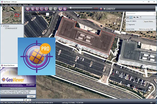
An all-in-one image viewer like the GeoViewer is accomplished for MrSID files, raster imagery, LiDAR point cloud data, and vector imagery. This standalone system allowed me a vantage point while exploring through a multi-level display.
I found the dynamic range adjustments along with other advanced options, exceptionally helpful in providing specific data that was unique to my project. In the full version, I was able to search by address. The ease of creating image files during export was the main feature that caught my attention. Otherwise, they allowed me to display my custom map drawings along with an option to print these portions.
License option: Deciding whether I would purchase the full version was a toss-up. The base software allowed access to raster, LiDar imagery, vector, WMS and JPIP sources, and LiDar imagery. I could also make use of the online basemaps while exporting my data.
With all the base features, I still thought, “more is better.” The five extra features added into the $50 pro version would pay for themselves.
Best for:
Anyone wanting to explore geospatial customizable maps will make use of the viewer, regardless of whether the user is professional or amateur.
2. MapViewer by PubWorks
Source: pubworks.com
Platform: The mobile version is IOS compatible, although any device, (including android) with a sign-in can access the system via the internet. The mobile version only complements the desktop rather than a replacement.
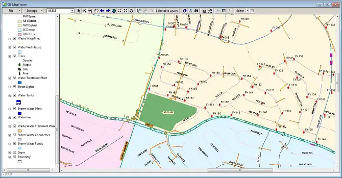
I thought PubWorks was a well-rounded map viewer. The ESRI overlay provided the means to combine my new data with the existing rom type data preventing any permanent changes.
Between mapping job costs, trouble spots, progress monitoring, and viewing completed work, PubWorks links its data to the GIS data. This process makes it possible for mapping work crews to create map-based agendas and explore costs. I appreciated the offline feature, which immediately synced my data upon returning to wifi.
License option: Users should request a demonstration. The software is not priced per seat and specifics are worked out before actual pricing is gauged.
Best for:
City officials and workers can make good use of PubWorks, and even citizens can access the software. Transparency and communication between officials and the public keeps everyone happy.
A good presentation can be found on YouTube.
3. ArcGIS Earth
Source: www.esri.com
Platform: Desktop versions and support for virtual environments give way to large-scale projects.
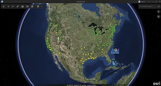
I was intrigued by watching the operator work the ArcGIS Earth. The demonstration made use of Keyhole Markup language recreating a 3D model of a June 6, 1944 event. The playback revealed a plane landing on Omaha Beach. Carefully inputting known data, the operator produced an enhanced representation of how the movie “Saving Private Ryan” depicted these events. The ArcGIS Earth manipulates and fuses KML to produce 3D images of interesting past events
The ArcGIS Earth makes use of featured tools including administration, cartography, automation imagery, and artificial intelligence. Support for virtual environments gives way to large-scale projects. The AI learns from models, making decisions based on IoT data, and provides insight on better decision making.
License option: A 21-day trial is available for the desktop software, and an individual basic pro-license starts at $100 per year. From here, licensing goes upwards including advanced access running $3,800 annually.
Best for:
ArcGIS Earth has many features suitable for the tinkerer, although its deep level of technology would suit more serious users.
The demonstration that so intrigued me can be viewed on YouTube.
4. GeoViewer by Nobel Systems
Source: www.nobel-systems.com
Platform: GeoViewer is designed to run on any device with a web-based browser and is intact with both online and offline modes.
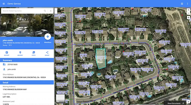
Viewing GeoViewer brought me to ponder on its many uses within government agencies, utility districts, and private organizations. Decision making concerning operational tasks such as dig alerts and leak management is based on the real-time smart mapping. The result is improved communication between and within these organizations allowing proper work orders to be submitted.
Some prominent features include spatial analytics, SaaS, and old data integration to stay connected with other departments and previous tasks. Average citizens can view data specific to their property while office and fieldwork are made efficient.
License option: Due to a wide variety of specific services and desired licenses, pricing is only available through the sales department. The service provided is well complemented, and demonstration requests are welcome.
Best for:
This viewer is well suited for government agencies, utility districts, and private organizations
View an informative YouTube video for more insight into GeoViewer.
5. QGIS

Source: qgis.org
Platform: Based on the ideas of Linux, QGIS works well inside Mac, OSX, Android, and even Windows.
The open-source community involved in building QGIS continues to support and improve the graphical information system. The effort reminds me of its host platform, Linux, in that due to volunteers within the community, the software is kept free. Saying that contributions are sought for continued development. The volunteers of QGIS report and fix bugs, along with document subscribers, and others handle the StackExchange. Donations of money are appreciated as well. Users support each other, keeping QGIS a free community-run software.
I found the GUI easy to navigate with tools to perform a multitude of tasks. Between the different platforms, the GUI remains similar. Functionalities include many vectors and raster formats. The software is well supplied with a custom experience due to the vast number of available plugins and community support to help along the way.
License option: Open-source licensing is made available through the continued user community support.
Best for:
Users with simplistic projects can make use of the viewer, although it has very in-depth features for more serious projects.
The video is quick-paced yet very informative.
6. SimpleGIS
Source: simplegissoftware.com
Platform: Desktop or tablet versions are available.
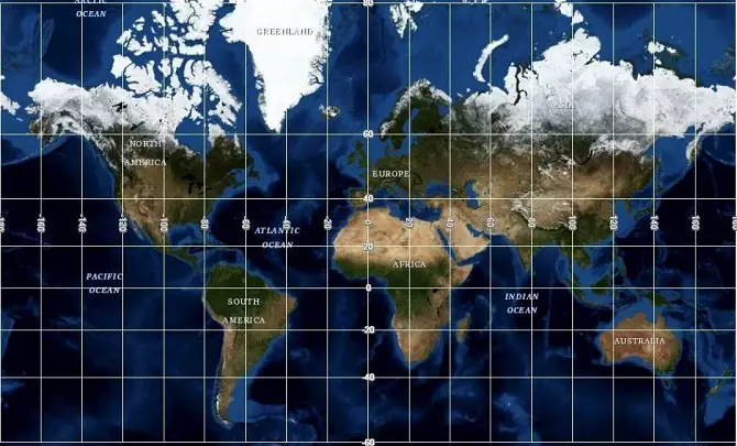
The SimpleGIS is best described as a compact, lightweight client yet still fully featured. I especially liked the landmarking abilities it possessed within the spatial mapping.
Besides topo maps, USGS imagery and aerial mapping brought more life to the design. I was also interested in the ability to bring in geocoding from multiple sources. Dozens of free mapping services are compatible with SimpleGIS.
TIF, jpeg, and SID imagery make up the raster format while industry-standard shaped files can be created from the vector data. Another neat feature allowed for scales and legends, giving the ability to choose feet, kilometers, miles, and even acres. I also found interest in the level of customization. Points, lines, or polygons can form grids, north pointing arrows, and legends.
License option: The trial lasts for 30 days and expires since there is no free version. After that, pricing starts at a one-time payment of $70.
Best for:
This viewer is well suited for all levels, and after a little practice, I can see a use for very complex projects.
A short video gives some good insight into SimpleGIS’s abilities and features.
7. GRASS GIS
Source: grass.osgeo.org
Platform: Linux, Mac, and Windows are supported making it available for desktops and most other devices.
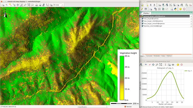
The GNU licensing of GRASS GIS was among the first things that caught my attention. It was started by a group of scientists and developers and continued its outward growth. I have to appreciate the community involvement, now consisting of a worldwide network of users. Everyone is encouraged to participate in its development, giving GRASS GIS its strength.
The library supports the most common GIS formats and 3D raster analysis supports map algebra, interpolation, and visualization. I found more impressive features in the temporal framework. It provides the raster and vector support, making big Spatio-temporal environmental data accessible. In the image processing, aerial and satellite data is used for classifying an object-based analysis chain.
License option: Open Source licensing is available and kept up through donations and support of the GRASS GIS community.
Best for:
I found the software useful in many complex scenarios, but it is relatively easy to operate.
A detailed webinar was very helpful in getting started with GRASS GIS.
8. GeoDa

Source: geodacenter.github.io
Platform: Windows, MacOSX, and Ubuntu.
I decided GeoDa was worth looking at with its 300,000 user base. The program features a user-friendly GUI for exploratory spatial data. It goes beyond viewing raw data maps, having a greater focus on tests and models of a statistical nature and their outcome.
Autocorrelation statistics work with thousands of records within point and polygon data. Interestingly, the multi-layered support covers local clusters including redcap, skater, spectral clustering, and max-p. Non-spatial clusters such as principal component analysis, k-means, and hierarchical clustering are also implemented. I was most impressed with seeing the data graphically stacked through time and rendered space
License option: The open-source has become a favorite among GIS enthusiasts, encouraging community involvement.
Best for:
There is something for everyone with a vast number of community-created plugins.
This detailed introductory video provides well-organized material to help get started.
9. MapViewer by Golden Software
Source: www.goldensoftware.com
Platform: Windows
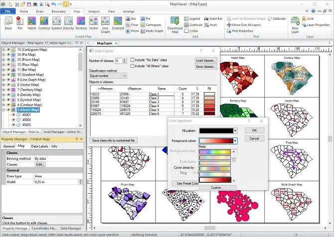
MapViewer left me enthused, checking out its geospatial data abilities. The advanced statistical map data is customizable and a good fit for the business world. The 16 various map types range from base to multi-graph, giving many options to communicate a specific message. I was able to experiment with tools allowing me to add text, shapes, color scales, and a wide variety of other customized parameters.
License option: Filling out a short form, including my reason for evaluating the software, provided a trial download link. There is no expiration although the absent print, save, copy, cut, and export commands may encourage paying. A single Windows license runs $459 and may be worth it for a frequent or ungenerous user.
Best for:
GIS-professionals who are looking for well-made software.
Watch this YouTube video for a MapViewer demonstration.
Closing Words
Not all GIS viewers are created equal, but after taking a closer look at nine of the best, there is something for every perceivable project. Between free and expensive or hobbies and complicated work tasks, a GIS is proven as a beneficial addition to our society. Choosing a GIS application comes down to fit the individual project to an application capable of meeting those parameters. See another review explaining the best laptops for GIS. If you wonder how to improve your professional skills, check my review of the best GIS certificate online programs.
