The geographic information system (GIS) framework is used to gather, process, and analyze spatial and geo-data. There are open-source (free to use) software solutions to consider if you work with a Mac computer. Also, many popular paid commercial GIS software has a version for the Mac. I review them and compare them so you can decide the software that is best for your intended use. Be sure to check the minimum system requirements for the GIS software you consider because this software is very demanding on system resources and works best on robust systems.
I grouped the reviews into two main categories, which are open source GIS software for the Mac that is free to use, followed by the choices for commercial paid software products.
Let’s take a look at 11 choices for GIS software that works on a Mac.
Open Source (Free) Software
These Softwares are free to use and might be no less convenient than commercial ones.
1. Google Earth Pro →

Description:
Google Earth Pro is free to download and use. With this software, you can import and also export GIS files to work with the data.
Features:
- Google Earth Pro allows using the historical data, collected over the past thirty years, to view past mapping information to make comparisons with the current imagery.
- The Google Earth Engine is a cloud-based service that offers a platform for data and analysis used by those interested in Earth science.
- This system offers a multi-petabyte collection of satellite images, planetary-scale analysis of geospatial datasets to observe changes, trends, and quantify differences on the Earth’s surface.
- Users apply custom algorithms to the satellite imagery dataset to create real-world applications.
- The application programming interface (API) for Google Earth Engine runs in Python and JavaScript making it easy for GIS analysts to use.
- Google offers a web-based code editor that allows the easy creation of custom algorithm development with immediate access to the multi-petabyte collection of satellite images.
License Option Price:
Goggle Earth Engine is free for non-commercial use for research, education, and non-profit organizations. Users must apply for a free account at earthegine.google.com and it takes one week for approval.
For commercial use, there are paid commercial licenses. You will need a valid Google API key and an account on the Google Cloud Platform. The first $200 of monthly usage (400,000 API requests) is included with a paid account to use the Google products of Maps, Routes, and Places. The billing is $0.50 per 1,000 API requests up to 100,000 requests daily.
Best for:
Those who can make use of the historical data files such as researcher studying climate change or other earth surface changes like erosion, waterway changes, desertification, etc.
2. GRASS GIS for Mac →

Description:
Geographic Resources Analysis Support System (GRASS GIS) is a Geographic Information System (GIS) technology created for the management of vector/raster geospatial data, analysis and geo-processing, visualization, and spatial modeling. The GRASS GIS project is affiliated with the Open Source Geospatial Foundation as one of its founding members.
Features:
- GRASS GIS has an intuitive graphical user interface (GUI) and command-line syntax used for data automation and production purposes.
- The software has more than 500 modules for processing and rendering geographic data.
- It works with vector, raster, and 3D formats.
- GRASS GIS is useful for basic to complex modeling and spatial analysis.
- GRASS GIS can connect to spatial databases and interface with any third-party software and data libraries.
- Handled image processing for aerial, UAV, and satellite data (MODIS, Landsat, Sentinel, etc.), supervised and unsupervised classifications, and a full Object Based Image Analysis (OBIA) chain.
- Offers point cloud analysis for LiDAR and interpolation.
- Has raster analysis for map algebra, masking, interpolation, and landscape analysis.
- Uses spatial statistics for correlation and covariance analysis, zonal statistics, and regression.
- The SQL database interfaces with SQLite, PostgreSQL, and others.
- Terrain analysis works with hydrological tools, contour and surface generation, and cost-path with slope-aspect analysis.
- Features vector analysis for topology corrections and generalization, buffer, network analysis, and overlays.
License Option Price:
GRASS GIS is free to use. It is open-source software released with a GNU General Public License (GPL 2.0).
Best for:
Grass GIS is one of the most powerful GIS systems that can be used by anyone doing GIS work at professional levels.
3. QGIS →

Description:
QGIS is a user-friendly, open-source Geographic Information System (GIS) made available for free use under the terms and conditions of a GNU General Public License. The Open Source Geospatial Foundation (OSGeo) developed QGIS. This software works with many types of databases. It supports raster and vector file formats.
Features:
- QGIS works with 2D and 3D vector and raster data files in different formats without the need to convert files to a standard format.
- The software has an easy-to-use graphical user interface (GUI) to compose maps and explore spatial data.
- Users can create, manage, edit, export, and analyze raster layers and vector files in many different formats.
- Complex analysis is possible using spatial databases and any OGR-supported formats.
- This software does sampling, geo-processing handles geometry, and offers database management tools.
- GRASS functionality offers more than 400 integrated modules.
- Publishes maps on the Internet using a webserver.
- Has an integrated Python console.
- Many plug-ins are available to extend QGIS functionality.
License Option Price:
This software is open-source and free to use.
Best for:
Students and professionals use this software. There are many global user groups in various countries offering support and development.
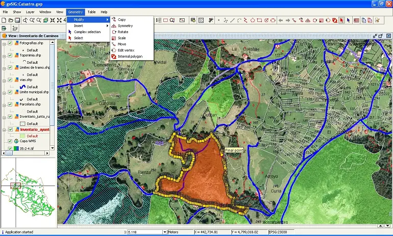
4. gvSIG →

Description:
gvSIG is open-source software that is used by many thousands worldwide for processing GIS data. It works with many databases and remote services as well as raster files and vector files. Because the software is open source it is easy to extend it. Developers continue to improve the software and create plug-ins to increase its functionality.
The gvSIG Online version is an integral platform used with Spatial Data Infrastructures (SDI) as a fast and robust solution to efficiently manage the spatial data of any organization.
Features:
- Has a quick start access guide.
- Users can use an on-premise version of gvSIG and share geographic information on the cloud through gvSIG Online, generate maps, geo-portals, and work with 2D and 3D applications.
- The gvSIG Mobile solution is an easy-to-use, robust, interoperable data collection system for a mobile device using the Android operating system.
- The gvSIG Roads is useful to manage road and highway infrastructures.
- The gvSIG Educa is an adaption of the gvSIG Suite to use for educational purposes.
- The gvSIG Batovi is a special educational version for the interactive teaching of geography students.
License Option Price:
The gvSIG program and gvSIG Online is free to use as open-source software under the GNU/GPL license.
Best for:
This software is used by private companies as well as local, regional, national, and worldwide organizations. The educational versions of this software are an excellent resource for teachers and students.
5. Whitebox GAT →

Description:
Whitebox GAT is an open-source, desktop version of GIS and remote-sensing software used for data visualization and analysis of geospatial information. Whitebox GAT provides a software platform for advanced analysis of geospatial data with applications in the geomatics industry and environmental research. It enables experimentation using innovative geospatial methods of analysis. It also is an educational tool used for geomatics training.
Features:
- Open access allows for experimentation with the development of geospatial algorithms.
- Offers direct insights into the inner workings of an algorithm’s design and its implementation. This increases the educational potential and improves innovation.
- Whitebox GAT allows users to view the source code for each part of the software from a tool’s dialog box by selecting the View Code option. There is no need to download separate source code files.
License Option Price:
This software is open-source, free to use, and extend.
Best for:
This software is very good for educational uses for those interested in learning more about the source code and creating custom algorithms.
6. uDig →

Description:
The uDig program is a user-friendly desktop version of an Internet-based GIS. It is an open-source application built with Eclipse Rich Client (RCP) software. It is an extendable stand-alone application, which works with RCP plug-ins and also can be a plug-in that works with another RCP application.
Features:
- This is a Java-based solution for desktop GIS data management.
- The software has a user-friendly GUI.
- The program runs as a thick client natively in the Mac OS/X.
- Enabled for Internet-based geospatial services (GeoRSS, KML, and tiles) working with the standards of WMS, WFS, and WPS.
- The program is a GIS-ready framework allowing complex analysis and the ability to add the capability to the main application.
License Option Price:
This is open-source software that is free to use and modify.
Best for:
This software offers detailed user documentation, a quick start guide, and walkthroughs to help a new user get started. Commercial consulting, training, and support are also available for new users who are willing to pay for help.
Commercial Paid Software
This section lists the most popular commercial GIS software for a Mac.
7. ArcGIS Online →

Description:
ArcGIS is the most popular commercial software. The desktop version does not work with a Mac. However, it is possible to use the cloud-based ArcGIS Online service with a Mac that has a high-speed Internet connection. With ArcGIS Online, you can make maps, work with GIS data, analyze the data, collaborate, and share maps and apps.
Features:
- This software supports many file types such as spreadsheets, GeoJSON, KML, and geospatial files.
- Using an add-on tool called ArcGIS Analytics for IoT, it is possible to connect to external observational data sources such as message brokers, IoT platforms, and third-party APIs.
- Offers intuitive analysis tools to better understand data in the context of location.
- This system allows adding demographic and environmental data to interactive maps.
- Collaborate with colleagues and share maps privately with groups or public or both.
License Option Price:
ArcGIS Online has a free trial and different pricing for individuals and businesses. Personal and student use is $100 per year. Business use depends on activity levels. There are various subscription levels that come with usage credits included (250 for worker/editors, 500 for creators/professionals). Additional usage credits can be purchased separately.
Best for:
Professional workers and students who want to use the most popular commercial GIS software to collaborate with others.
8. DroneDeploy →

Description:
DroneDeploy is the leading drone software system for collecting geospatial data. It is used by over 5,000 companies in agriculture, construction, roofing, solar energy systems, inspection services, mining, and the oil & gas industry.
Features:
- This system has drone flight controls, data collecting, and processing.
- The software handles drone operations management for flight operations, compliance, and integrations.
- Offers enterprise management for global drone operations.
- Integrates with other enterprise systems including Procore, Autodesk BIM 36, Bluebeam, OneDrive, Egnyte, Sharepoint, Azure, Box, Google Drive, Dropbox, Skyward, AirMap, Roof Report, John Deere, Drone Insurance, Claimant, FieldView, Agremo, Verifly, Drone Logbook, ArcGIS and many more.
License Option Price:
The individual plan is $149 per month or $99 per month if billed annually. The business plan is $449 per month or $299 per month billed annually. Enterprise plans are quoted for the numbers of users.
Best for:
This system is for specialists who work with drones for mapping.
9. Avenza MAPublisher →

Description:
MAPublisher software integrates more than 50 GIS mapping tools with Adobe Illustrator to create stunning maps. The software works with industry-standard GIS data formats and geo-referencing data.
Features:
- Works with popular formats such as Esri, Google, MapInfo, WFS/WMS services, and other GIS sources.
- MAPublisher tools manage map layers, attributes, and plot points. Use the software to create and edit theme style sheets and selection filters.
- This software creates web maps and maps designed for display on mobile phones.
License Option Price:
There is a free trial. A fixed license is $1,399 for installation on one computer. A floating license is $2,699, which allows sharing with multiple people. These prices include one-year tech support and upgrades. To upgrade from 8.x or 9.x versions is $599 and it is $899 to upgrade from the previous versions of 7.x software.
Best for:
The floating license is cost-effective for commercial use, academic environments with many students, and non-profit organizations.
10. Cartographica →

Description:
Cartographica is designed specifically for the macOS. It is for people who work with geospatial data for map creation and GIS data analysis. It is easy to convert between formats and discover insights about geospatial data.
Features:
- There is a large range of data import capabilities using raster and vector data.
- It is easy to import online map data from a web map server such as Live Map from Bing Maps or OpenStreetMap.
- There is rapid data filtering using a search box with multi-variable search and boolean operators.
- The software offers sophisticated layouts, flexible styles, layer transparency, direct editing, and undo support to reverse changes made.
- The software offers simultaneous data and map browsing, geo-coding, intelligent project management, GPS support, easy navigation, direct database access, and geospatial analysis.
License Option Price:
This software has a one-time purchase price of $495 for commercial use. There is a discount price of $346.50 for academic and student use. Students enrolled in a degree-granting institution can also get a license while enrolled in school for $99 per year.
Best for:
This software is best for those who want to produce beautiful maps with software designed for use on a Mac for an economical price.
11. Manifold →

Description:
Manifold is a super-fast GIS that delivers robust data science capability for routine GIS tasks. It handles Big Data with improved quality over ESRI or other GIS systems.
Features:
- Manifold runs all cores in a computer to increase processing speed substantially.
- ESRI processes that take over ten minutes can be finished by Manifold in ten seconds.
- Manifold allows a user to create a master for all table data, drawings, maps, images, raster data, and vector geometry.
- This software connects to multiple sources for blending, preparing, extracting, transforming, loading, analyzing, validating, visualizing, and exploring your data.
- Manifold combines GIS visual and spatial information with massive data processing power using a built-in parallel database management system.
License Option Price:
The price is only $95, fully paid. The Manifold Viewer is free.
Best for:
Those who want professional, superior quality, super-fast, classic GIS at a very low price.
The Bottom Line
This list has everything available for the macOS that you will need for studying GIS or professional work. You can get a lot of power from the open-source software and you should give Manifold a try for its blazing fast speed. Also, take a look at our recommendations for the Best GIS Certificate Programs if you are thinking about taking a course to become GIS certified.